


Disclosure: This article contains affiliate links. We may earn a commission from purchases at no extra cost to you, which helps our travel content.
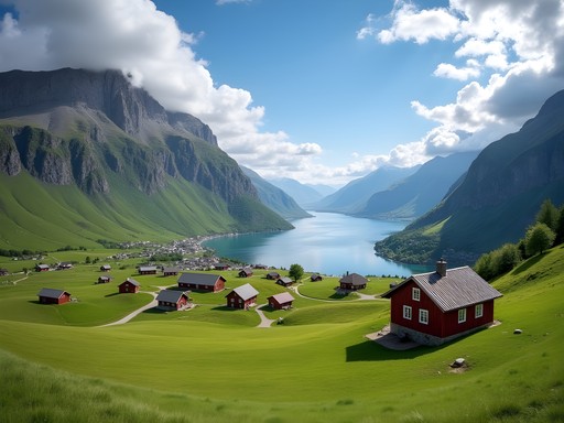
Standing at the edge of Aurlandsfjord, with the morning mist still clinging to the emerald slopes, I felt that familiar surge of excitement that comes with discovering a place where nature's grandeur remains largely untouched. Flam may be known for its iconic railway, but beyond the well-trodden tourist path lies a network of hiking trails that showcase Norway's commitment to preserving its natural wonders while making them accessible to conscious travelers. As someone who believes in experiencing destinations through mindful footsteps, I'm thrilled to share these five trails that balance adventure with environmental respect.

The Flam Valley Circuit: Where History Meets Sustainability
The 8km Flam Valley Circuit offers the perfect introduction to the region's blend of cultural heritage and natural splendor. Beginning near the railway museum, this moderately challenging loop takes you through verdant farmlands that have been sustainably managed for generations.
What struck me most was witnessing Norway's pioneering approach to agricultural preservation. Local farmers have implemented innovative water management systems that protect the valley's delicate ecosystem while maintaining traditional farming practices. Along the route, interpretive signs (powered by small solar panels) explain how these communities have balanced tourism with environmental stewardship.
The trail climbs gradually through birch forests before opening to panoramic views of the fjord. I recommend packing a proper meal for this 3-4 hour journey—my group found the perfect picnic spot at the halfway point overlooking the valley. My collapsible hiking poles proved invaluable during some of the steeper sections, especially when navigating the rocky terrain after recent rainfall.

💡 Pro Tips
- Start early (around 8am) to avoid crowds from arriving cruise ships
- Visit the local information center for a free trail map with sustainability initiatives marked
- Pack layers—the temperature can vary significantly between the valley floor and higher elevations
Brekkefossen Waterfall Trail: Accessible Adventure for Groups
For groups with mixed hiking abilities, the Brekkefossen Waterfall Trail offers the perfect balance of accessibility and reward. This 3km round-trip hike begins right from the center of Flam village and climbs steadily to one of the region's most impressive waterfalls.
Despite its relatively short distance, don't underestimate the elevation gain—you'll climb about 240 meters through a series of switchbacks. The trail designers have thoughtfully incorporated resting points with educational placards about local flora and the watershed's importance to the region's biodiversity.
What makes this trail particularly special for groups is its natural gathering points. The main viewing platform can comfortably accommodate 15-20 people, making it perfect for group photos and collective moments of awe. During our visit, we encountered several multi-generational families enjoying the hike together—proof that nature's wonders can bring diverse ages and abilities together.
I always recommend proper footwear for any hike, and this trail's occasionally slippery sections reinforced that wisdom. My waterproof hiking boots provided excellent traction on the damp stones near the waterfall's spray zone—an investment that has paid dividends across countless trails.

💡 Pro Tips
- Take frequent water breaks during the climb—the elevation gain is more challenging than the distance suggests
- Bring a lightweight rain jacket even on clear days—the waterfall creates its own microclimate
- Visit in late afternoon when the light creates rainbows in the waterfall mist
Aurlandsdalen Lookout Trail: Norway's Sustainable Tourism Showcase
The 7km Aurlandsdalen Lookout Trail represents everything I admire about Norway's approach to sustainable tourism development. This moderately difficult trail climbs steadily from the Flam valley floor to a series of increasingly spectacular viewpoints overlooking Aurlandsfjord.
What sets this trail apart is how Norwegian conservation authorities have thoughtfully developed the route to minimize environmental impact while maximizing the experience. The path follows natural contours where possible, with carefully constructed stone steps in steeper sections that blend seamlessly with the landscape. Rest areas feature benches made from locally sourced timber, and educational signage explains the delicate alpine ecosystem.
The crown jewel of this hike is the Stegastein Viewpoint—an architectural marvel extending 30 meters from the mountainside, 650 meters above the fjord. While many tourists drive to this lookout, reaching it on foot offers a profound sense of achievement and connection to the landscape.
During our hike, rapidly changing weather conditions reminded me why proper gear matters in Norwegian mountains. My packable down jacket proved essential when clouds rolled in, dropping temperatures significantly at higher elevations. Equally important was staying properly hydrated—my insulated water bottle kept water cold throughout the day's journey.

💡 Pro Tips
- Download the Norwegian Trekking Association app for offline trail maps and safety information
- Allow 4-5 hours for the complete round trip, including time to appreciate the viewpoints
- Check weather forecasts carefully—conditions can change rapidly at higher elevations

Rimstigen Historical Trail: A Cultural Time Capsule
For those seeking to connect with Norway's cultural heritage alongside natural beauty, the Rimstigen Historical Trail offers a fascinating journey through time. This challenging 4km (one-way) route was once the main path connecting the fjord settlements with mountain farms before modern roads existed.
The trail begins near the Viking-era Flam Church and climbs steeply through a series of switchbacks, gaining approximately 650 meters in elevation. What makes this hike special is the preserved cultural elements along the way—ancient stone walls, foundations of mountain dairy farms, and traditional rest shelters that have served travelers for centuries.
Local conservation groups have done remarkable work maintaining this historical route while ensuring minimal environmental impact. Informational placards share stories of the families who once made seasonal migrations between fjord and mountain pastures, carrying supplies along this very path.
During our ascent, I found myself imagining the generations who had traversed these same stones, often carrying heavy loads of supplies. The physical challenge of the hike creates a profound connection to the historical experience. My hiking daypack proved perfect for carrying essentials while maintaining freedom of movement on the steeper sections.
At the trail's highest point, we encountered a local guide conducting an impromptu session on traditional Norwegian mountain farming practices—an unexpected educational bonus that highlighted the community's commitment to preserving cultural knowledge.

💡 Pro Tips
- Start no later than 10am to ensure enough time for the round trip and historical exploration
- Bring binoculars to spot remnants of old farm structures on distant mountainsides
- Download the Flam Cultural Heritage app for audio stories about specific points along the trail
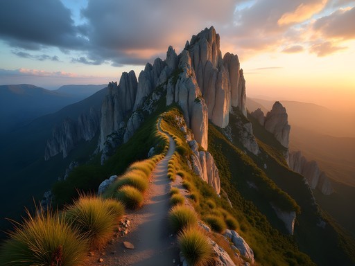
Bakkanosi Ridge Trail: For the Adventure Seekers
I save the Bakkanosi Ridge Trail for last because it represents the pinnacle of hiking experiences in the Flam region—both literally and figuratively. This challenging 16km trail is not for casual hikers, but for those willing to invest the effort, the rewards are incomparable.
The trail begins in the neighboring village of Aurland and climbs steadily through changing ecological zones—from lush valleys to alpine terrain. The final approach to Bakkanosi Ridge requires careful navigation across rocky terrain, but the panoramic views from the 1,398-meter summit plateau are nothing short of life-changing. On clear days, you can see not only Aurlandsfjord but multiple surrounding fjords and the distant peaks of Jotunheimen National Park.
What makes this hike particularly special from a sustainability perspective is how it remains largely undeveloped despite its increasing popularity. Norwegian outdoor ethics emphasize leaving minimal trace, and the local hiking association has resisted adding infrastructure that would detract from the wild character of the route.
This hike requires serious preparation. We departed at dawn with ample supplies and navigation tools. My GPS hiking watch proved invaluable for tracking our progress and ensuring we maintained appropriate timing for a safe return before dusk. For energy throughout the 8-10 hour journey, I relied on energy bars which provided sustainable fuel without excessive packaging waste.
The most profound moment came at the summit, where our group sat in contemplative silence, absorbing the vastness of Norway's fjord landscape—a powerful reminder of why preserving these natural spaces matters so deeply.

💡 Pro Tips
- Register your hiking plan with local authorities or your accommodation before attempting this trail
- Pack emergency supplies including first aid kit, headlamp, and extra layers regardless of weather forecast
- Consider hiring a local guide if you lack extensive mountain hiking experience
Final Thoughts
As I boarded the train leaving Flam, my legs pleasantly tired from a week of exploration, I reflected on how these five trails had revealed layers of Norway that most visitors never experience. Beyond the postcard views, I discovered a culture deeply committed to sustainable tourism—where conservation, education, and responsible access intersect beautifully. These trails offer more than just physical journeys; they provide windows into Norway's approach to preserving natural wonders while making them accessible to those willing to tread lightly.
Whether you're traveling with friends seeking adventure or colleagues looking for team-building experiences in nature, Flam's trails offer something uniquely powerful—the opportunity to disconnect from digital noise and reconnect with both the natural world and each other. The conversations that unfold while navigating a challenging section of trail often reveal more about your companions than weeks in conventional settings.
I encourage you to venture beyond Flam's famous railway, lace up your hiking boots, and discover these paths less traveled. In doing so, you'll not only witness breathtaking landscapes but also support a community that has thoughtfully balanced tourism with environmental stewardship. The memories you create—of morning mist rising from fjords, of wildflowers clinging to impossible slopes, of silence broken only by distant waterfalls—will remain long after your footprints fade from Norway's ancient paths.
✨ Key Takeaways
- Flam offers hiking experiences for all ability levels, from accessible waterfall trails to challenging summit adventures
- Norway's approach to sustainable tourism is evident in thoughtful trail design and educational elements
- Proper gear and preparation are essential for safety and enjoyment in the changing mountain conditions
- Group hiking in Flam creates unique bonding opportunities through shared natural experiences
- Visiting during summer months provides optimal conditions and longest daylight hours for exploration
📋 Practical Information
Best Time to Visit
June through August
Budget Estimate
$150-200 per day including accommodations and meals
Recommended Duration
5-7 days
Difficulty Level
Moderate To Challenging

Comments
Sage Dixon
Douglas, love how you captured the essence of Flam beyond just the famous railway! The Aurlandsdalen trail absolutely blew my mind when I hiked it two years ago. That moment when you reach the lookout and see the entire valley spread below you - I stood there for probably 30 minutes just taking it in. One thing I'd add for readers: the trail conditions can change quickly with weather, so I always keep my hiking GPS charged and bring a proper trail map as backup. The sustainable tourism initiatives you mentioned are so important - it's refreshing to see destinations getting it right. Can't wait to return and tackle the Rimstigen trail I missed!
sunnywalker
This is EXACTLY what I needed!! Going in June and so excited now. Thank you for all the details about the trails 🙌
summertime
What's the weather like in September? Trying to decide between early or late season visit. Also curious about accommodation options in Flam itself - is it better to stay there or base yourself in Bergen?
Sage Dixon
September can be beautiful but unpredictable - bring layers! I'd recommend staying in Flam for at least 2-3 nights so you can really explore the trails without rushing. The village is small but has decent options, and waking up right by the fjord is magical.
roamking
Been there! Absolutely epic views
George Hayes
Great post, Douglas! We took our kids (8 and 11) on the Flam Valley Circuit last August and it was honestly one of the highlights of our Scandinavian trip. The historical farm buildings along the way kept them engaged, and we packed a picnic lunch to enjoy at one of the viewpoints. Pro tip: Start early in the morning to avoid the cruise ship crowds. The sustainable tourism focus there is really impressive - our kids learned so much about conservation. Would love to hear more about the best time of year to visit for families!
sunnywalker
This is so helpful! Planning a family trip for next summer
nomadwanderer
How difficult would you say the Brekkefossen trail is? I'm not super experienced but really want to visit Norway this year
Sage Dixon
Brekkefossen is actually perfect for beginners! It's well-maintained and the elevation gain is gradual. I did it last summer with friends who rarely hike and they loved it. Just take your time and bring plenty of water.
nomadwanderer
Thank you so much! That's really helpful
photogal
Those waterfall photos are absolutely stunning!! Adding this to my bucket list right now 😍
scandinavian_dreamer
That shot of the morning mist on the fjord is absolutely magical! What time of day was that taken?
hikingaddict23
Is the Flam Valley Circuit doable as a day hike? Or should I plan to split it over two days?
escapeexplorer
Definitely doable in a day! We started around 9am and finished by 4pm with plenty of photo stops and a nice lunch break.
Jean Wells
Douglas, your analysis of sustainable tourism practices in the Aurlandsdalen area is particularly insightful. Having visited numerous mountain regions across Asia that are struggling with overtourism, I find Norway's approach refreshing. The trail infrastructure in Flam appears to balance accessibility with environmental protection remarkably well. One question: is there a particular season you'd recommend for these hikes? I'm considering either early June or late August for my visit next year and wondering about crowds versus optimal weather conditions.
mountain_wanderer
Not the author but I went in late August last year and it was perfect! Fewer tourists than summer peak, comfortable temperatures (15-20°C), and the waterfalls were still flowing well.
Jean Wells
That's helpful, thank you! Late August sounds ideal then.
Venture X
Premium card with 2X miles, $300 travel credit, Priority Pass