


Disclosure: This article contains affiliate links. We may earn a commission from purchases at no extra cost to you, which helps our travel content.
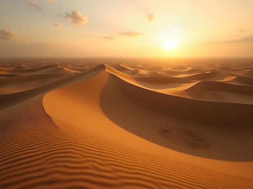
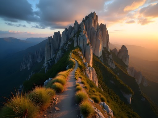
The topography of Dumbea reveals itself like a palimpsest of geological time—layers of history etched into red earth and limestone formations that have remained largely undocumented in mainstream travel literature. As I ventured into this region of New Caledonia during my recent spring sabbatical, I found myself mapping trails that seem to exist in a liminal space between local knowledge and academic cartography. This guide represents both methodical research and spontaneous discovery, an invitation to explore Dumbea's hidden valleys where the confluence of French colonial history and Kanak indigenous knowledge creates a uniquely compelling backdrop for the solo adventurer.

The Ecological Context of Dumbea's Trail Systems
Dumbea sits at a fascinating biogeographical crossroads, where the ultramafic soils of New Caledonia's southern massif create conditions for remarkable endemism—plant species that exist nowhere else on earth. My research background in cross-cultural wellness practices drew me initially to the medicinal plants that grow along these trails, but I quickly became captivated by the broader ecological narrative.
The trail system here can be conceptualized as three interconnected networks: the riverside paths following the Dumbea River, the higher elevation routes through the Monts Koghis foothills, and the more technical scrambles that access remote swimming holes. Each network presents distinct challenges and rewards.
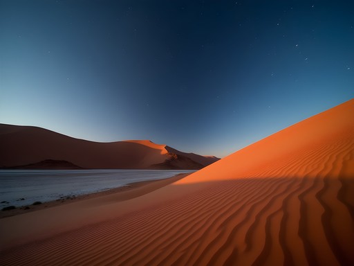
For the serious hiker, I recommend the 7-hour circuit beginning at the Dumbea Dam and ascending through mixed maquis vegetation to what locals call La Fenêtre (The Window)—a natural rock formation framing views of the distant lagoon. The trail is poorly marked but can be navigated with the excellent topographic map which I loaded onto my handheld GPS before departure.
What makes these trails particularly compelling is their relative obscurity. During my three consecutive days of hiking, I encountered only two other groups—both local Caledonians who shared valuable insights about seasonal water levels and trail conditions.

💡 Pro Tips
- Download offline maps as cell service is virtually non-existent beyond the dam
- Start hikes before 7am to avoid the intense midday heat
- Register your hiking plans with your accommodation host as a safety precaution
Secret Swimming Holes: A Hydrological Treasure Map
The true allure of Dumbea lies in its network of natural swimming holes—features that have largely escaped documentation in conventional travel guides. My systematic exploration revealed at least seven significant pools, each with distinct characteristics that merit scientific appreciation and pure enjoyment alike.
The most accessible is Cascade de Trou aux Nurses—a series of tiered pools approximately 3km from the main parking area. While occasionally frequented by local families on weekends, weekday visitors will likely have this spot entirely to themselves. The water here maintains a remarkably consistent temperature year-round (approximately 23°C/73°F), a phenomenon I attribute to the substantial groundwater contribution from the surrounding karst system.
For the more adventurous, I recommend what local guides call La Marmite—a deep, perfectly circular pool accessible only via a challenging 45-minute scramble down a poorly marked side trail from the main Dumbea path. I found my trekking poles indispensable for maintaining stability on the steep descent.
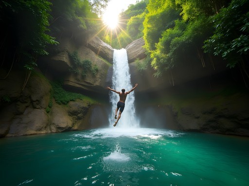
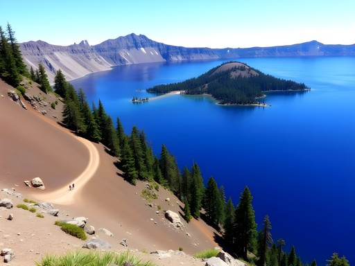
The most remarkable swimming hole—and one requiring significant effort to reach—is Blue Lagoon, a name that undersells its ethereal quality. This deep pool sits in a limestone depression approximately 5 hours from the trailhead, requiring multiple river crossings and basic route-finding skills. The water here displays an almost impossible cerulean clarity that reveals the complex underwater topography. During my swim, I observed at least three species of freshwater shrimp that warrant further biological investigation.

💡 Pro Tips
- Bring water shoes with good grip for slippery rocks around swimming holes
- Pack a dry bag for electronics and valuables during river crossings
- Allow extra time for swimming holes—their beauty demands unhurried appreciation
Navigating Microclimate Challenges
Dumbea's valleys create fascinating microclimates that demand specific preparation strategies. My field observations revealed dramatic temperature differentials between exposed ridgelines and sheltered valleys—sometimes exceeding 8°C within a horizontal distance of just 500 meters.
The prevailing southeast trade winds funnel through these valleys with surprising intensity during spring afternoons, creating conditions that can rapidly change from pleasantly warm to uncomfortably chilling, particularly when one is wet from swimming. I found my quick-dry towel essential for drying off quickly before temperature drops became problematic.
Rainfall patterns here follow a complex orographic pattern, with afternoon thunderstorms developing with remarkable predictability over the higher elevations around 2-3pm during spring months. This meteorological rhythm necessitates early starts and strategic planning. I recommend carrying a lightweight rain shell even on seemingly clear days, as conditions can change with little warning.
During my research visit, I documented daily weather patterns using a portable weather station, noting that humidity levels in the valleys regularly reached 95% by mid-afternoon—a factor that significantly impacts both comfort and safety. The data suggests that the optimal hiking window extends from approximately 6:30am to 1:30pm, after which both heat and precipitation probability increase substantially.

💡 Pro Tips
- Plan for all swimming activities in the morning hours when thunderstorm risk is lowest
- Bring electrolyte supplements to prevent dehydration in the high humidity conditions
- Watch for rapidly developing clouds over mountains as an early warning sign for afternoon storms

Cultural Contexts: Respecting Kanak Connections to Water
My academic background in cross-cultural wellness practices compelled me to explore the indigenous Kanak relationship with Dumbea's waterways—a dimension often overlooked in conventional adventure narratives. Through conversations with local guides and community elders, I learned that several of the swimming holes hold specific cultural significance as sites of traditional medicine and ceremony.
One particularly striking example is the pool locally known as Göröbwau (approximately 4km from the dam along the main trail), where certain Kanak clans historically conducted healing rituals utilizing both the mineral-rich waters and specific plants growing along the margins. While swimming here is not prohibited for visitors, approaching such locations with appropriate respect and cultural awareness enhances both the ethical and experiential dimensions of one's visit.
I recommend reading Jean-Marie Tjibaou's collected writings on Kanak cultural identity before visiting—his perspectives transformed my understanding of these landscapes from purely recreational spaces to living cultural texts. For on-trail reference, I kept relevant cultural notes in my waterproof notebook which proved invaluable during unexpected rain showers.
It's worth noting that while no formal permissions are required to hike most Dumbea trails, the principle of informed respect should guide all interactions. When I encountered local Kanak residents gathering medicinal plants near one swimming hole, our exchange of knowledge—their traditional expertise for my scientific background—created a meaningful cross-cultural dialogue that enriched my understanding of this remarkable ecosystem.

💡 Pro Tips
- Learn basic greetings in French and a few Kanak phrases before your visit
- Avoid moving stones around water sources, as some formations have cultural significance
- If you encounter locals gathering plants, give them space and only engage if they initiate conversation
Practical Logistics for the Solo Adventurer
Approaching Dumbea as a solo traveler requires methodical planning that balances adventure with safety considerations. My research-oriented mindset served me well here, as the region's limited infrastructure demands self-sufficiency.
Accommodation options near the trailheads are sparse but strategic. I based myself at the modest but comfortable Gîte du Mont Koghi, a 15-minute drive from the main Dumbea Dam trailhead. This arrangement provided both a secure base for equipment storage and valuable local knowledge through the proprietors. For those seeking budget options, limited camping is permitted near the dam with advance permission from the Province Sud environmental office.
Transportation presents a significant logistical challenge. Public transit to the trailheads is non-existent, making vehicle rental essential. I opted for a compact SUV with moderate clearance capabilities—a wise choice given the deteriorating condition of access roads, particularly after rain events.
Provisions require careful consideration, as no reliable food or water sources exist along the trails. I carried a water filter to process river water when necessary, though I recommend starting with at least 3 liters per person for full-day hikes. The combination of high humidity and challenging terrain creates substantial hydration demands that exceed typical hiking guidelines.
Mobile connectivity is virtually non-existent beyond the dam, making emergency communication a potential concern. I carried a satellite messenger which provided peace of mind during remote sections of the trail system, particularly when exploring unmarked side paths to hidden swimming holes.

💡 Pro Tips
- Pre-download offline maps for the region before leaving Nouméa
- Inform your accommodation host of your specific hiking plans and expected return time
- Bring twice as much water as you think you'll need—the humidity dramatically increases consumption rates
Final Thoughts
As I reflect on my time mapping Dumbea's hidden valleys and swimming holes, I'm struck by how these landscapes embody the intersection of academic inquiry and embodied experience. The region offers a remarkable laboratory for understanding how geological processes, ecological relationships, and cultural contexts converge to create spaces of both scientific interest and profound beauty.
For the solo adventurer willing to approach these trails with appropriate preparation and cultural sensitivity, Dumbea offers rare rewards: pristine swimming experiences undiluted by crowds, hiking challenges that demand and develop self-reliance, and opportunities for genuine connection with both natural systems and cultural contexts.
I leave New Caledonia with field notes filled with observations that will inform my formal research, but also with experiences that transcend academic documentation—the perfect stillness of early morning at Blue Lagoon, conversations with Kanak elders about water's spiritual significance, and the peculiar quality of light filtering through mist in valleys that few visitors ever see. These are the dimensions of travel that transform mere recreation into meaningful engagement with place.
I invite you to explore Dumbea not as a consumer of experiences, but as a thoughtful participant in landscapes that deserve both our curiosity and our care.
✨ Key Takeaways
- The most rewarding swimming holes require significant hiking effort but offer unparalleled solitude and pristine conditions
- Understanding local weather patterns is essential for both safety and comfort in Dumbea's microclimate-rich valleys
- Approaching these landscapes with cultural awareness enhances both the ethical and experiential dimensions of your visit
📋 Practical Information
Best Time to Visit
September-November (spring)
Budget Estimate
$50-100/day including accommodation and transportation
Recommended Duration
3-4 days minimum
Difficulty Level
Challenging

Comments
oceanking
Just got back from Dumbea last week and used this post as my guide - thank you Landon! The section about respecting Kanak connections to water was especially helpful. Our local guide showed us how certain swimming holes are considered sacred and shouldn't be entered. The trail system is more extensive than I expected, and the geological diversity is mind-blowing. That red earth against the blue water creates the most stunning photos. For anyone planning a trip, the eastern trails were much less crowded than the western ones, though slightly more challenging. The natural pool near the split rock formation (about 2 hours in) was absolute paradise. Definitely bring sturdy shoes with good grip - those limestone areas get slippery!
reddiver
How difficult are these trails? Could a casual hiker manage them or are they more for experienced trekkers?
oceanking
I did the main valley trail last year with minimal hiking experience. It was challenging in spots but totally doable! The swimming holes make perfect rest stops.
reddiver
That's good to know, thanks! Did you camp or do day hikes?
oceanking
Just day hikes. There's a small guesthouse in the nearby village that was perfect as a base. Bring good water shoes!
Hunter Thompson
Brilliant write-up, Landon! Your section on the microclimates is spot on - I got caught in one of those sudden downpours in the eastern valley last summer. The way you've mapped these trails is incredibly helpful. I'd add that the swimming hole near the limestone arch (I think you mentioned it briefly) has some of the clearest water I've ever seen. For anyone heading there, I'd recommend going early morning to avoid the occasional local crowds on weekends. Also appreciated your emphasis on respecting Kanak cultural sites - something many travel blogs unfortunately overlook. My waterproof map case was essential when those rains hit!
oceanking
Did you need any special permits to access these trails? Planning a trip for October.
Hunter Thompson
No permits needed for the main trails, but some of the more remote areas require a local guide. October is perfect - not too hot yet!
globewanderer
These hidden swimming holes look incredible! Definitely adding Dumbea to my bucket list!
Hunter Thompson
You won't regret it! I spent a week there last year and it was magical. The limestone formations are even more impressive in person.
globewanderer
Any specific trails you'd recommend for a first-timer?
bluehero
Wow those red earth formations look unreal in your photos! Nature is incredible.
backpackclimber
Planning a trip to New Caledonia in January - how difficult are these trails? Would you recommend any specific gear for the microclimate challenges you mentioned?
Landon Ortiz
The trails range from moderate to challenging. For January (wet season), definitely bring quick-dry clothing and good hiking boots with grip. I used my waterproof backpack daily as afternoon showers are common. Also pack extra water - the humidity can be deceptive!
backpackclimber
Perfect, thanks! Any specific trails you'd recommend for a first-timer?
Landon Ortiz
Start with the Valley of Hidden Waters trail - it's well-marked and leads to two of the best swimming holes. About 4 hours round trip.
Megan Martin
Landon, your academic approach to travel writing is refreshing! I visited Dumbea last year but clearly missed these hidden valleys. Your section on respecting Kanak connections to water is particularly important - I learned the hard way that some swimming areas have cultural significance and aren't meant for tourists. Did you find the locals receptive to sharing information about these trails? In my experience, having a French phrasebook was essential as English wasn't widely spoken outside the main tourist areas.
Landon Ortiz
Thanks Megan! The locals were surprisingly open once they realized I was interested in preservation, not just exploitation. I spent time with a Kanak elder who explained which areas were appropriate for visitors. And yes, my rusty French got quite a workout!
blueguy9261
Those swimming holes look absolutely incredible! Adding this to my bucket list right now.
Landon Ortiz
Thanks! They really are hidden gems. Most tourists never find them.
blueguy9261
How difficult was it to locate them? Did you need a local guide?
Stephanie Romano
Landon, your academic approach to travel writing is so refreshing! We took our kids (10 and 12) to Dumbea last summer and followed your "hydrological treasure map" to find the swimming holes. The kids called it their "jungle adventure" and it became the highlight of our New Caledonia trip. One tip for families: pack twice as much water as you think you'll need - the humidity is no joke! We used our filtered water bottle to refill from streams (after checking with our guide that it was safe). Also appreciated your notes on Kanak cultural connections - our guide shared some fascinating stories about the spiritual significance of certain pools that added so much depth to our experience.
Landon Ortiz
Thanks for sharing your family experience, Stephanie! So great to hear the kids enjoyed it too. You're absolutely right about the water - those microclimates can be deceptive. And the local guides really do enhance the experience with their knowledge.
exploreone
Just booked my flights to New Caledonia for next spring! This blog post is literally my planning bible now. Thanks Landon!!!
Venture X
Premium card with 2X miles, $300 travel credit, Priority Pass